The map of your website shows your boat trip. In order to update the position of your boat, several different systems can be used to gather your position from your IridiumGo, your AIS device, your phone, etc...
Each of these systems/trackings operates independently and in competition with each others. You can thus have the AIS module that will update your position during your coastal navigation and at the same time have the IridiumGo module configured so that you can continue to update your position during blue water passages.
![]()
All trackings are available for Premium and Pro subscriptions.
Your tracking trace
All these system will update you tracking trace . The map can contain several traces, but only one contain your starting point and your current boat position. This default trace will be updated by the trackings.
Update frequency
The time between each update varies depending on the module. For example for the AIS module, the position will be retrieved from the AIS network every 2 hour. On the other hand there is no delay for the Telegram module. The difference is explained by the resources (computational and financial) required for each module. You will find the update times for each module in their respective configuration page.
![]()
AIS tracking delay display
Can I use multiple tracking systems at the same time?
Yes. You can configure and use as much tracking as you want. That said, each system checks whether the position sent to it is chronologically after the last one on the map and whether it is more than 0.1 nautical mile away.
Does tracking work everywhere?
It depends on your location and your devices used to receive and transmit your position. AIS coverage is not global (no access to satellite AIS data at this time) and depends on your distance to a terrestrial relay. You won’t have a coverage problem close to high-traffic areas. But overall AIS coverage is pretty good.
On the contrary you will have a worldwide coverage with Iridium satellites (up to 70°N/S), or SPOT tracking.
For other trackings:
- If you have an internet connection (Iridium, Starlink), you can update your location via E-mail, Telegram and API.
- If you have a functional Iridium installation you can update your position via IridiumGo and E-mail.
- If you have an HF radio capable of sending and receiving emails, you can update your location via Airmail and E-mail.
What is the minimum distance between two positions?
1 nautical mile; within this distance from the position previously reported on the map (by any tracking), the new position reported will not be added. This avoids overpopulation of position report when the boat does not move (at anchor or marina) and it also avoids having too much data which would lengthen the loading time of your map on your site.
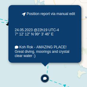
Add other data (speed, heading, comment) with a position report
With some tracking system you can provide additional data and comment. For E-mail, Airmail and API systems (as well as for the manual addition of position on the map) you can add to your position your speed, heading and a comment. If one of these parameters is added to the position, a waypoint icon ![]() is added to the tracking trace. Your visitors will then be able to hover over these icons to display additional information
is added to the tracking trace. Your visitors will then be able to hover over these icons to display additional information